
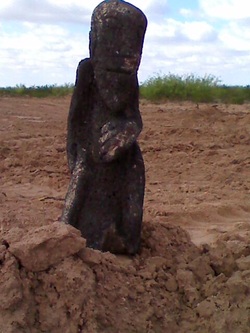
Basalt Figurine 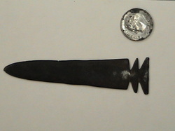
Metal Projectile Point 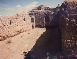
Pueblo Ruins |
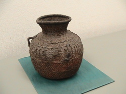
Apache Basket 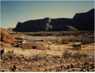
Butterfield Overland stage stop |
Cultural History
This overview of the prehistory and history of southeastern New Mexico, specifically the lower Pecos River to the Texas border, is designed to address two areas. First, this overview will briefly outline broad temporal periods and mention some of the previous fieldwork that was used in their definition in southeastern New Mexico. A discussion section follows and addresses theoretical and methodological issues that affect our knowledge of that temporal period. The methodological discussion includes information that can be derived from survey and excavation.
Paleoindian (ca. 20,000 to 6,200 B.C.)
The beginning of human occupation of the eastern slopes of the Sacramento Mountains is unknown. Evidence for limited use of the area from at least 20,000 years ago has been documented from Pendejo Cave located on the eastern edge of the Tularosa Basin (MacNeish and Libby 2004).
The earliest record of human occupation in southern New Mexico is indicated by the occurrence of generalized lithic toolkits associated with the remains of Pleistocene mammals and plants with radiocarbon dates ranging back to forty thousand years ago at Pendejo Cave near Oro Grande (MacNeish and Libby 2004). With the exception of a possibly earlier complex from Hermit's Cave, the Paleoindian period in southeastern New Mexico is characterized by distinctive lanceolate projectile points. Three distinct phases have been recognized for the Paleoindian period in southeastern New Mexico; Clovis, Folsom and Plano (Katz and Katz 1993). Sites with Paleoindian components have been recovered from lower elevations in areas that have been exposed through erosion. These types of Paleoindian points have been recovered as isolated finds, in association with later occupations, and with extinct Pleistocene fauna (Hammack 1964; Hester 1971). By examining the contexts of these different kinds of discovery situations in the Pecos drainage of New Mexico, some suggestions can be made regarding the chances for the recovery of Paleoindian remains within that region.
Much has been made of the presence of Paleoindian remains occurring in areas subject to erosion (Cordell 1979). Most Paleoindian sites in southern New Mexico bear this out. Soils within the proposed survey area are sandy loams or loamy sands, are often shallow, and subject to erosion (Maker et al. 1971). Early sites can be found in eroded areas as this process removes later soil deposits, exposing the artifacts.
Poorly dated sequences of soil development are within the Pecos drainage area south of Fort Sumner and elsewhere in southeastern New Mexico (Hall 2002; Jelinek 1967; Nials et al. 1977, Nials 1980). Through the use of this data, areas where there is a likely chance of recovering in situ Paleoindian remains could be identified, such as in arroyos and the eroded shorelines of lake beds. As many excavated Paleoindian sites exhibit multiple components, there is the chance that much of the occupations are mixed with later cultural material. Such mixing precludes understanding such things as lithic reduction sequences or spatial patterning in activity areas. Single component Paleoindian sites found through modeling buried site locations based on the age of soil horizons would contribute much to the understanding of these early cultures. Geomorphic features of late Pleistocene age are located within the confines of the survey area increasing the probability of recovery of Paleoindian remains (Fiedler and Nye 1933; Hall 2002).
Archaic Period (ca. 6,200 B.C. to ca. A.D. 200)
The term Archaic is used here to refer to post Pleistocene hunter and gatherer adaptations and not a segment of a general or evolutionary trend. The lengthy Archaic period begins with a post Pleistocene drying trend that produced an essentially modern climate regime around 6000 B.C. Prehistoric occupants of this period adapted to a desert grassland and scrub environment with increased spatial and seasonal variability in subsistence resources.
The Archaic period in southeastern New Mexico is not as well understood as that in the lower Rio Grande. This is due to a combination of poor site integrity in areas of erosion and the lack of extensive archaeological excavation projects. Deflation of the soil surface tends to mix occupations as well (Hall 2002).
Little independent chronological information is available for Archaic occupations in southeastern New Mexico. Archaic sites are most commonly dated by the presence of different styles of projectile points. Many sites contain projectile points whose styles have been assigned to different ages elsewhere or produce projectile points that span a considerable period. Such points may not be useful for estimating the time placement of the site or indicate reoccupation during the time of that particular styles popularity (Duran and Laumbach 1981a, 1981b; Hammack 1964; Zale 1983).
The Archaic Period of southeastern New Mexico is characterized by a foraging adaptation in a biologically modern environment. Extensive Archaic occupations have been documented in both upland and basin locations of southeastern New Mexico (Kilby and McNally 1994; Sebastian and Larralde 1989). The most recent culture history framework applicable to the Archaic period of southeastern New Mexico was developed by Katz and Katz (1993). Few earlier dated Archaic components have been reported from southeastern New Mexico. The total number of dates from archaeological sites increases in number through time, although this trend is as likely to represent the total number of sites exposed or disturbed through erosion as opposed to evidence of intensity of occupation.
Extensive surveys of public lands and examination of private collections has been conducted by amateur archaeologists for a number of years (Leslie 1978, 1979). This work suggests that the local Archaic tradition, divided into an early and late stage is more similar to that of west Texas than that of western New Mexico.
A more localized Archaic sequence based primarily on excavation data has been formulated for the Brantley Dam on the Pecos River (Katz and Katz 1985). Much of the material for this synthesis is based on the excavation of buried single component sites that have been dated by radiocarbon. Unfortunately, few sites for each of the Archaic phases were excavated so little is known of inter-phase variability. Evidence of plant and animal processing and pit baking of mussels was recovered.
Discussion
Important differences exist between the Archaic periods of the lower Rio Grande and southeastern New Mexico. In the lower Rio Grande, seasonal sedentism was part of the adaptive strategy as well as some horticulture, although this latter aspect did not become important until the succeeding Formative period. Archaic sites in southeastern New Mexico lack evidence of permanent features except for the possible wells at Blackwater Draw (Evans 1951), suggesting a more mobile lifestyle that appears to continue into the Formative period. Possible Archaic storage features and a dog burial have been reported from a site near Mayhill (Green 1956).
Some attempts have been made to differentiate Archaic lithic scatters from Formative age lithic scatters lacking ceramics using differences in reduction strategies and material types (Chapman 1983; Lord and Reynolds 1985). While these type of studies have increased awareness of the variability between lithic assemblages. and encouraged intensive lithic analysis during the undertaking of surveys, such analysis may not be appropriate. The model of changing lithic technologies assumes that there is a change in lifestyles between the Archaic, Formative and Protohistoric Periods. Data from excavations at Santa Rosa Lake indicate that little change in terms of mobility and subsistence practices took place between the Archaic and subsequent Formative Periods (Schelberg and Akins 1987a, 1987b; Kauffman 1983).
The major focus of Archaic research in both regions should first be chronology building using reliable technique including radiocarbon, Optical Stimulated Luminescence, and archaeomagnatism. These will not only aid in a general strengthening of chronologies, but if this program is extended to sites lacking projectile points; those sites can be assigned to a specific time period.
Dating sites is especially important in southeastern New Mexico where little is known of the relationship between sites found along the Pecos River and related drainages and those sites on the plains and shinnery oak belt (Beckett 1976). Larger patterns of regional mobility are indicated by the frequent recovery of ceramics in the sand hills of southeastern New Mexico that were produced using materials local to the Sacramento Mountains (Hill 2006).
Where plant remains are preserved, studies need to be undertaken of prehistoric diets. Cultigens become at least a small part of the Archaic diet in the lower Rio Grande but may never have been exploited in southern New Mexico until the Formative period, and then only to a limited extent. Clearly, much remains to be done regarding differences in the development of subsistence and settlement systems in these two areas.
In the case of archaeological survey, more description of the types of lithic materials present on sites, the type of reduction strategy and evidences of tool recycling reflected in the lithic assemblage should be conducted (Hogan 2006). The presence of fire-cracked rock, even when not articulated into a feature should be recorded. With the advent of Optically Stimulated Luminescence dating, burned caliche can be as useful for dating an occupation as the presence of charcoal.
FORMATIVE PERIOD
There is an increase in the number of sites with radiocarbon dates around 2000 years ago (Katz and Katz 1993). The Archaic 4 phase extends from A.D. 1 to 500 and is marked by the presence of medium-sized, stemmed dart points and the absence of ceramics (Katz and Katz 1993).
Recent research has revised the introduction of ceramics into southeastern New Mexico to A.D. 200, contemporary with ceramics recovered from other sites in southern New Mexico (Hill and Staley 1997). Based on this dating, the Formative 1 should be expanded to the A.D. 200-750. Dart points have been found to persist through Formative 2, around A.D. 950. In southeastern New Mexico, it appears that prehistoric people retained several aspects of an Archaic lifestyle except for the introduction of ceramics. Also, the morphology of the ground-stone tools and the materials used in their manufacture suggest that wild foods and not agricultural products were being processed.
Horticulture may never have played an important role in subsistence in southeastern New Mexico. Little or no indication of corn has been reported until around A.D. 1000 (see Zamora 2000), with the only evidence coming from sites with architecture along the Pecos River and its western tributaries (Akins 2003; Kelly 1966, Leslie 1979; Wiseman 2002). Some of these pueblos on the flanks of the Sacramento and Capitan Mountains have produced exotic ceramics from the west, Alibates dolomite from the Texas Panhandle and copper bells from Mexico (Kelly 1984). The use of pitstructures or brush huts continues into well into the Formative period (Wiseman 1981; Zamora 2000).
Once away from the major drainages, the archaeology of the Formative period consists of scattered camps with extensive groundstone assemblages for processing seed crops such as mesquite, shinnery oak and various annuals. Ring middens have been noted on the slopes of the mountains to the west and in the Carlsbad karstic region (Katz and Katz 1987, Mera 1938). Some of these ring middens may also relate to Apache use of leaf succulents, based on slight technological differences from the prehistoric variety and the association of one ring midden with a metal projectile point from Brantley Dam (Katz and Katz 1987). These camps could represent evidence of a period of seasonal mobility by the inhabitants of the villages along the rivers or the presence of full time hunter gatherers. An extensive number of ring middens dating to the Formative period have also been documented along the eastern flanks of the Sacramento and Guadalupe Mountains demonstrating the importance of this food source (Zier 2000).
The final phase of the Formative period is apparently characterized by a shift from a emphasis on gathering and horticulture to bison hunting (Jelinek 1966; Speth 2004; Speth and Perry 1980). Interestingly, the faunal remains from the Henderson site located on a tributary of the Pecos River north of Roswell, and dating to the later thirteenth and early fourteenth century, indicates a diet that included a substantive portion of bison that was supplemented by corn-based horticulture (Speth 2004). The dramatic increase in the presence of bison remains at the Henderson site presages the shift to a mobile lifestyle evidenced by bison kill sites in southeastern New Mexico in the fifteenth century.
Discussion
Much has been made of the variability in the degree of sedentism practiced by Formative groups resident in southeastern New Mexico (Hill 2006; Hogan 2006). However, without good chronological control it is difficult to assign a site to a specific time period in order to include it into a settlement model. The first order of business is good independent chronological control over sites beyond the presence of projectile points and decorated ceramics since many of the sites in these regions have been demonstrated to have lengthy occupations that may range over several thousand years (Kauffman 1984). Independent dating will allow sites to be assigned to a specific time period and isolate periods of reuse of the same locality.
During surveys, attention needs to be paid to variations in the artifact assemblages and the environmental context of each site. Ceramics need to be described in terms of formal attributes. The practice of in-field ceramic analysis will serve to create a data-base for examining regional patterns of interaction and could provide additional evidence of site re-occupation. The circulation of a standard for the description of rock types and lithic tool descriptions will further aid in the collection of consistent data (Hogan 2006).
PROTOHISTORIC PERIOD (A.D. 1540 through Early Sixteenth Century)
While Navajo materials dating between A.D. 1450 and 1500 have been well documented in northwestern New Mexico, evidence for Apache occupation of the Great Plains is not found until the time of Spanish contact (Gunnerson and Gunnerson 1988, Hill 1991). Recent research is changing this picture of Apaches as late arrivals into southeastern New Mexico (Seymour 2004). Coronado was told by the inhabitants of Pecos Pueblo in 1540 that the Teyas (possibly an Apachean group) had come into the area only about sixteen years earlier (Winship 1898).
Recent research regarding the presence of Apaches in southern New Mexico is based on the presence of late radiocarbon dates from isolated hearths and from agave roasting middens and the occasional metal projectile point. Recent excavations of a large site with an Apache component located on Ft. Bliss can be used as a model for what sorts of materials might be recovered from Apache sites in southeastern New Mexico (Seymour 2004).
HISTORIC PERIOD (Sixteenth through Early Twentieth Century)
The Historic Period has been traditionally viewed as beginning with the arrival of Coronado in 1540. The presence of Coronado's expedition in the Rio Grande Valley and a single excursion across the plains probably did not have the local impact that the expedition of Antonio de Espejo did while traveling down the Pecos River on the way back to Mexico in 1583. No Indians were observed in the area between present-day Santa Rosa and Fort Sumner. A well used trail, possibly a game trail, paralleled the Pecos River along the east site on which the expedition traveled through this area (Hammond 1929). Expeditions sent out from Pecos Pueblo by Gaspar Castaño de Sosa also failed to locate any Indians south of the pueblo, but probably did relocate the trail along the Pecos mentioned by Luxan during the Espejo expedition (Schroeder and Matson 1965).
That the Spanish expeditions did not encounter Apaches in the area is unusual, and could be due to several factors including the expeditions coinciding with a seasonal round that did not include riverine resources at that time or fear of the Spanish based on stories passed on from Puebloan trading partners. Certainly the remains of Apachean groups in the form of tipi rings are common in the Fort Sumner area. These tipi ring sites have not been independently dated and are attributed to the historic period by the presence of historic Puebloan ceramics (Stewart, Batcho, and Hill 1986). While a number of tipi rings have been excavated, they tend to produce few artifacts or independent dates (Hammack 1964, Mobley 1983).
While there appears to have been some exploitation of the Middle Pecos drainage in the earlier nineteenth century by sheepherders, the area was not systematically investigated until 1850 by Captian Henry B. Judd who first mapped the Pecos River and traveled down it covering much of the same route as the Spanish explorers almost three hundred years earlier (Jelinek 1966).
In 1866, two Texas ranchers, Charlie Goodnight and Oliver Loving, decided to drive their cattle along the Pecos River to Fort Sumner and Santa Fe (Sebastian and Levine 1989). This cattle trail, in spite of episodic raids by Apaches continued to be used until the coming of the railroads some twenty years later.
Fort Sumner was established in 1862 to provide protection for Euro-American ranching enterprises from Apaches. It also served as a reservation where it was assumed that Apaches and Navajos would learn to farm and give up their mobile lifestyle. In all almost 9,000 Athabascans speaking peoples were interred at Fort Sumner between 1863 and 1868. (Sebastian and Levine 1989). In reality, due to poor water, soil, and overpopulation, the experiment in forced sedentism failed miserably (Sheridan 1975). The sustaining area for the fort included the current project area where Apaches and Navajos would travel to collect wood. Navajo ceramics have been reported from just south of the current project area (Jelinek 1967).
Little historical archaeology had been conducted in southern New Mexico. This is unfortunate since archaeology can give a better rounded picture of history than written records that tend to focus on individuals and special events, rather than on social processes and adaptive behavior.
Unlike research on the Rio Grande, which focused on military sites, historical archaeology in along the Pecos drainage, with the exception of Fort Sumner, has focused on individual homesteads (Olsen and Wilson 1976). Some of this work has been conducted in conjunction with the prehistoric archaeology at Brantley Dam (Katz and Katz 1987). One early settlement has been excavated west of Roswell (Oakes 1987). This site was examined for the purposes of providing baseline data for understanding differences in ethnic behavior between Hispanic and Euro-American settlers in territorial New Mexico. Using a combination of archaeology and historical records, the history of the Ontiberos family was traced from the purchase of land and its subsequent development and eventual sale.
The major force driving Euro-American settlement of southeaster New Mexico was the Stock-Raising Homestead Act signed by Abraham Lincoln on May 20th, 1862. This act allowed settlers who occupied up to 160 acre sized parcel of public land for six months and then paid $1.25 per acre would be given title to that land. The Homestead Act was modified in 1909 which expanded the size of the available land parcels to 320 acres. The Homestead Act was again amended in 1916 and renamed the Stock-Raising Homestead Act to allow for the homesteading of 640 acres parcels.
Discussion
Like prehistoric archaeology, historical archaeology, can provide information about how people have adapted to changing social, economic and environmental conditions. Through the inclusion of historical archaeology in a program of regional research, much can be learned of the total range of human use of the landscape.
In theory, materials could be present representing early Apaches, Spanish explorers, sheep and cattle ranching, American Military and Navajos. Detailed descriptions, drawings, and photographs should be made of temporally and/or culturally diagnostic artifacts for later comparisons with published literature. Features and structures should be documented as well. Land title searches need to be conducted for habitation structures to look at patterns of ethnicity and time periods of settlement and abandonment.